Connect this guide with the rest of your visit in the Osaka trip planner. Read how the research is made and what its sources establish.
At a glance
Start here
- Osaka developed around river mouths, waterways, and trade routes.
- Nakanoshima moved from storehouse and exchange functions toward civic and cultural roles.
- Bridges are both transport infrastructure and records of the city's form.
- A river-level route reveals relationships hidden by a station-to-station itinerary.
01
Water is part of Osaka's structure
Osaka City describes the urban center as a Water Corridor, with rivers forming a distinctive circuit through the city. The municipal history also locates Osaka's development around the mouths of the Yodo and Yamato rivers, where waterways supported transport and exchange. Water therefore belongs to the city's basic geography rather than to a later tourism theme.
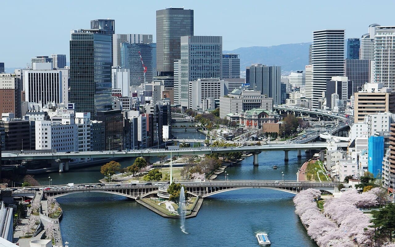
That structure changes how visitors can read the map. Nakanoshima lies between the Dojima and Tosabori rivers. Osaka Castle connects to the Okawa and other waterways. Dotonbori's canal belongs to a southern entertainment landscape. Moving along the water shows why major districts developed in relation to landing places, crossings, warehouses, and trade.
- Look for river names before station names on a planning map.
- Notice where islands, bends, and bridges concentrate public buildings.
- Treat canals as historical transport corridors, not only photo backdrops.
02
Trade turned waterways into city systems
The city's official account links the Port of Osaka, overseas trade, and the development of canals and rivers with economic and cultural growth. Goods did not simply arrive at the bay; they had to move through an urban distribution system. Water routes, landing areas, bridges, and commercial districts operated together.
This helps explain Osaka's long association with food and wholesale commerce without reducing the city to a slogan. Agricultural products, rice, and other commodities moved into spaces where they could be stored, priced, exchanged, and distributed. The visible river today is only one part of that earlier network, but its alignment preserves the logic of movement.
- Connect port history with inland distribution.
- Read bridge approaches as former points of concentrated movement.
- Use museums and official historical material to interpret waterways that have changed.
03
Nakanoshima carried the merchant city
Osaka's official visitor guide describes Edo-period Nakanoshima as a place of storehouses belonging to domains from around the country, with rice and other commodities traded there. Its position between two rivers was functional. Storage and exchange could sit inside the same transport landscape that moved goods toward the commercial city.
Nakanoshima later accumulated government, economic, and cultural institutions. The shift did not erase the island's earlier role; it changed the kind of public importance attached to the same geography. A walk from the eastern park toward the museum district therefore crosses layers of commerce, administration, education, performance, and art without leaving the island.
- Begin at the eastern park for the clearest island shape.
- Continue west to watch civic buildings give way to larger cultural institutions.
- Cross at least one bridge to see the island from outside it.
04
Bridges record movement and change
Osaka City's profile treats bridges as essential to the Aqua Metropolis story because they supported life and commerce while changing in form over time. A bridge is not only a crossing. It fixes a relationship between banks, channels traffic toward particular streets, and creates a viewpoint from which the scale of a river becomes legible.
Walking both a riverbank and a bridge produces two different readings. From the bank, building fronts and promenades define the edge. From the span, the channel, neighboring bridges, and island geometry become visible. This is why a water-city route should include crossings rather than following one side of Nakanoshima from start to finish.
- Pause without blocking pedestrian movement.
- Compare the upstream and downstream views.
- Notice whether streets meet the bridge directly or turn along the water.
05
The Public Hall marks a civic layer
Osaka City Central Public Hall stands between the two Nakanoshima rivers. Its official history records construction beginning in 1913 after a donation by Iwamoto Einosuke and completion in 1918. The building later underwent a major preservation and restoration project, reopening in its restored form in 2002.
The hall demonstrates how a commercial city produced civic architecture and cultural gathering space. Its Neo-Renaissance exterior addresses the river landscape, while its continuing use prevents it from becoming a detached monument. Public interior viewing is limited because the building operates as a venue, so check current access rather than expecting every room to be open.
- View the exterior from across the river as well as from the island.
- Use the official exhibition-area information for any interior visit.
- Distinguish a functioning venue from a museum with full public circulation.
06
Museums extend the island's cultural role
The Museum of Oriental Ceramics was established by Osaka City after the donation of the Ataka Collection and sits within Nakanoshima Park. Farther west, art and science institutions continue the island's cultural concentration. Their presence makes Nakanoshima more than a landscaped pause between business districts.
The ceramics museum's official description emphasizes East Asian collections and purpose-built display methods. That focus also reflects Osaka's history of exchange: objects, collectors, companies, and civic institutions meet in one museum story. Do not assume permanent collection objects are always on view; consult the current exhibition calendar before connecting a historical argument to a specific display.
- Choose a museum by its current program.
- Use the river walk to connect institutions without rushing through all of them.
- Read collection origins as part of Osaka's civic and commercial history.
07
Read the Water Corridor in the present
Osaka City reports continuing waterfront work around pedestrian paths, docks, cruise lines, and river-oriented commercial spaces. The present landscape is therefore managed and changing, not a preserved historical scene. Modern promenades can reveal older waterways while also reflecting current planning priorities.
Aqua-Liner services connect the Osaka Castle and Nakanoshima water landscape from river level, according to official visitor information. Treat a cruise as one possible perspective, not as the definition of the water city. Check the operator's current route and operating notice. A self-guided bridge-and-bank walk remains useful when schedules or conditions do not fit.
- Check live cruise operation before building a day around it.
- Keep a walking version of the route.
- Use the water to connect history, architecture, and present-day public space.
Useful answers
Reader questions
Why is Osaka called a water city?
Rivers, canals, port trade, and bridges shaped the movement of goods and the city's development. Osaka City calls the central river circuit the Water Corridor and continues to plan around it.
Sources: City of Osaka; City of OsakaWhere is the clearest place to see Osaka's water-city history?
Nakanoshima is the most concentrated starting point because its rivers, former storehouse role, civic architecture, parks, and museums can be read in one east-to-west walk.
Sources: Osaka Convention and Tourism Bureau; Osaka City Central Public Hall; The Museum of Oriental Ceramics, OsakaDo I need a river cruise to understand the Water Corridor?
No. A cruise offers a river-level view, but a route using banks and bridges can reveal the island geometry and public buildings. Check current cruise operations if you want to add one.
Sources: Osaka Convention and Tourism Bureau; City of OsakaCan I enter Osaka City Central Public Hall?
Some exhibition and free-viewing areas may be available, but the hall is an operating venue and broader access is limited. Check the official page for current viewing arrangements.
Sources: Osaka City Central Public HallRead the evidence
Sources and further reading
These sources support the relevant sections above. Plans and comparisons are editorial suggestions. Check operators for current arrangements.
- Increasing the city's appeal ↗City of Osaka · Research date 14 September 2026
Official Water Corridor description, links between port trade and waterways, and present-day waterfront planning.
- Profile of Osaka city ↗City of Osaka · Research date 14 September 2026
Development around the Yodo and Yamato river mouths and the historical and landscape role of bridges.
- Nakanoshima ↗Osaka Convention and Tourism Bureau · Research date 14 September 2026
Island geography, Edo-period storehouses and trade, and later civic and cultural concentration.
- About the Public Hall ↗Osaka City Central Public Hall · Research date 14 September 2026
Location, donation and construction history, Neo-Renaissance architecture, restoration, and limited public viewing.
- The Museum of Oriental Ceramics, Osaka ↗The Museum of Oriental Ceramics, Osaka · Research date 14 September 2026
Museum foundation, collection origins, East Asian scope, display approach, and Nakanoshima Park location.
- Osaka Suijyo Bus Aqua-Liner ↗Osaka Convention and Tourism Bureau · Research date 14 September 2026
Official description of the Okawa, Osaka Castle, and Nakanoshima river route and need to check current service.